
Park is seeking individuals who would like to go hiking to remark trails.
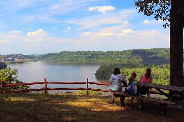
Susquehannock State Park is located in southern Lancaster County, overlooking the Susquehanna River south of the Holtwood Dam.
Curtis Sherwood, a Dept. of Conservation & Natural Resources Tech is seeking volunteers who would be willing to “go hiking with a spray-paint bottle or two and a stencil to re-mark our blazes at Susquehannock State Park.”

To inquire, Please Contact the park at (717) 252-1134 or [email protected]
With the weather starting to turn spring, this may be the perfect opportunity to get out of the house and help your community at the same time.
Chimney Trail
0.35 mile, more difficult hiking
This wooded trail is great for birding and viewing spring wildflowers.
Fire Trail
0.33 mile, more difficult hiking
Actually a short logging road, this trail features a nice stand of poplar trees.
Five Points Trail
0.7 mile, most difficult hiking
Hikers can see rhododendron and views of creek valleys from this trail.
Holly Trail
0.5 mile, easiest hiking
Native holly and Christmas fern line this easily hiked trail.
Landis Trail
0.6 mile, more difficult hiking
Named for Lester Landis, a former owner of the historic Long Home near the park office, this trail features a fine stand of Virginia bluebells that bloom in late April and early May.
Nature Trail
0.3 mile, easiest hiking
This trail features mature hardwood trees, ferns, and wildflowers.
Overlook Trail
0.55 mile, more difficult hiking
This popular trail leads to Hawk Point and Wisslers Run overlooks, which offer memorable views of the Susquehanna River.
Pine Tree Trail
0.31 mile, most difficult hiking
This short, steep and rocky hike winds its way down to Wisslers Run.
Pipeline Trail
0.24 mile, easiest hiking
This leisurely stroll follows an old, abandoned pipeline right-of-way that crosses the park.
Rhododendron Trail
1.2 miles, most difficult hiking
The park’s longest and most difficult trail crosses steep and rocky terrain and rewards the hiker with spectacular rhododendron blooms during late June and early July. Remnants of the homestead of Thomas Neel and an impressive beech tree can be seen along this trail.
Spring Trail
0.4 mile, easiest hiking


